
Engineering and Environmental

Home | Engineering and Environmental

Protecting Namibia’s Natural Resources

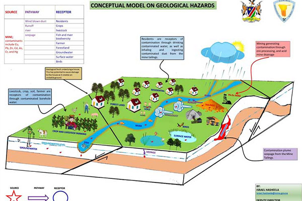
The Engineering and Environmental Geology Division within the Geological Survey of Namibia (GSN) plays a crucial role in safeguarding Namibia’s vulnerable natural resources and addressing geological hazards. Our division consists of two subdivisions: Environmental Geology and Engineering Geology.

Through our dedicated efforts, the Engineering and Environmental Geology Division contributes to the sustainable development of Namibia’s natural resources and the protection of the environment.

Environmental Geology Subdivision

Focus

  • Protecting water, soil, and biodiversity in mining environments.

Activities

  • Investigating geochemical contamination from mining operations. Collecting and analysing samples of soil, water, vegetation, and air. Interpreting findings and generating contamination maps. Preparing interpretive reports with recommendations for stakeholders.

Key Divisional Activities

These are carried out at or in surrounding areas of mining activities.

  • Soil Contamination Investigation: Regular environmental monitoring to assess soil contamination from mining activities.
  • Ground and Surface Water Contamination Assessment: Regular environmental monitoring to assess soil contamination from mining activities.
  • Strategic Environmental Management Plan (SEMP) for the Uranium Province: Assessing cumulative impacts of uranium mining on various environmental and socio-economic factors i.e air quality, groundwater, infrastructure, etc.
  • Air Quality Management: Developing an Air Quality Management Plan (AQMP) for the Erongo Region to mitigate air pollution from mining and other industries.
  • Risk Assessment of Abandoned Mines: Risk assessments of legacy mines

Engineering Geology Subdivision

Focus

  • Investigation of Engineering Geological problems on various soil and rock formations, as well as generating data and information for land use planning.

Key Activities

  • Investigation of geological hazards, providing geo-engineering advice to stakeholders, mapping, generating, and managing engineering geological data, and operating a rock and soil mechanics laboratory.

Engineering Geology Projects

  • Regional Engineering geological mapping: To ensure safe designs in various land-use development.
  • Investigation of land degradation due to soil erosion.
  • Investigation of seasonal ground cracks in soil formation across various regions.